The Atlas Mountains are one of Morocco’s most remarkable geographical features, stretching across the country and shaping its landscapes, climate, and culture. For travelers, researchers, and geography enthusiasts.
Understanding the Atlas Mountains on a map provides valuable insight into Morocco’s diverse terrain. From snow-capped peaks to fertile valleys and traditional Berber villages, the mountain range plays a central role in the nation’s identity.
When examining a map of morocco atlas mountains, it becomes clear that the range is not a single chain but a vast system of mountains extending through Morocco and into neighboring countries. In Morocco, the Atlas Mountains cover a significant portion of the interior, creating a natural barrier between coastal regions and the Sahara Desert. Their strategic location has influenced trade routes, settlement patterns, and agricultural practices for centuries.
Geographic Location of the Atlas Mountains
The map of morocco atlas mountains stretch across North Africa, passing through Morocco, Algeria, and Tunisia. In Morocco, the range runs diagonally from the southwest to the northeast, dividing the country into distinct climatic and ecological zones. On most maps, the mountains appear as a series of interconnected ranges that occupy the central and southern parts of the country.
The Moroccan section of the Atlas Mountains is generally divided into three main regions: the High Atlas, the Middle Atlas, and the Anti-Atlas. Each region has unique characteristics and contributes to the country’s varied landscape. Understanding these divisions is essential when reading a mountain map or planning travel through the region.
The High Atlas Region
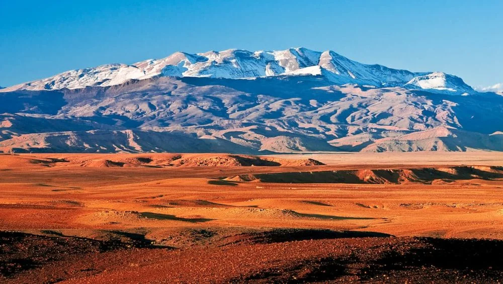
The High Atlas is the most famous and highest section of the mountain system. It contains Mount Toubkal, the tallest peak in North Africa, rising to over 4,000 meters. On maps, the High Atlas forms a prominent chain that runs across central Morocco, south of major cities such as Marrakech.
This region is known for dramatic scenery, including rugged peaks, deep valleys, and winding mountain passes. Many trekking routes and outdoor adventures are concentrated here. The High Atlas also serves as a vital water source, feeding rivers that support agriculture in nearby regions.
The Middle Atlas Region
Located north of the High Atlas, the Middle Atlas is characterized by rolling hills, forests, and plateaus. This area is less rugged but equally important in Morocco’s geography. Maps often show the Middle Atlas stretching toward cities like Fez and Meknes.
The region is famous for cedar forests and diverse wildlife. It also receives higher rainfall than many other parts of Morocco, making it an important agricultural area. Travelers exploring this region often encounter scenic lakes, green landscapes, and charming mountain towns.
The Anti-Atlas Region
South of the High Atlas lies the Anti-Atlas, a more arid and ancient mountain range. On geographical maps, it appears as a separate chain extending toward the Sahara Desert. Although lower in elevation, the Anti-Atlas has unique geological formations and breathtaking desert landscapes.
The region is home to traditional villages, oasis communities, and historic trade routes. Its rugged terrain provides a striking contrast to the greener areas of the Middle Atlas, highlighting Morocco’s incredible environmental diversity.
Why Atlas Mountains Maps Are Important
Maps of the map of morocco atlas mountains serve many purposes beyond simple navigation. They help travelers understand elevation changes, road networks, hiking routes, and regional boundaries. Geographers use these maps to study climate patterns, water systems, and geological structures.
For tourists, mountain maps are especially useful when planning visits to remote villages or trekking destinations. The terrain can vary significantly within short distances, making accurate mapping essential for safe and efficient travel.
In addition, maps reveal how mountain ranges influence transportation routes. Roads often follow valleys and passes, while settlements tend to cluster around water sources created by mountain runoff. Understanding these relationships helps visitors appreciate the practical importance of the mountains.
Climate Influence of the Atlas Mountains
One of the most significant features visible through geographical analysis is the role the Atlas Mountains play in shaping Morocco’s climate. The mountains act as a natural barrier that affects rainfall distribution and temperature patterns across the country.
Regions north and west of the mountains generally receive more precipitation, supporting agriculture and forests. Areas to the south experience drier conditions that gradually transition into desert landscapes. This climatic division is a key reason Morocco contains such diverse ecosystems within a relatively small geographic area.
Snowfall in the higher elevations of the High Atlas is another important factor. Melting snow contributes to rivers and reservoirs that provide water for cities, farms, and rural communities throughout the year.
Cultural Significance of the Mountain Range
The map of morocco atlas mountains are not only a geographical landmark but also a cultural treasure. Many indigenous Amazigh (Berber) communities have lived in these mountains for centuries. Maps often highlight villages and settlements that preserve traditional architecture, languages, and customs.
Mountain communities have adapted to challenging terrain through terrace farming, livestock herding, and local craftsmanship. Visitors exploring the region gain insight into a way of life that has remained closely connected to the natural environment.
Historical trade routes crossing mountain passes also contributed to cultural exchange between different regions of Morocco. These routes connected coastal cities, inland markets, and desert caravans, helping shape the country’s rich heritage.
Popular Destinations Found on Atlas Mountains Maps
Several destinations stand out when studying mountain maps of Morocco. Marrakech serves as a major gateway to the High Atlas, attracting travelers seeking outdoor adventures. Mount Toubkal is a leading destination for hikers and climbers from around the world.
The Middle Atlas offers attractions such as cedar forests and picturesque towns, while the Anti-Atlas provides access to dramatic desert scenery and historic kasbahs. Each region offers a unique perspective on Morocco’s natural beauty and cultural diversity.
Many maps also highlight national parks, trekking trails, and scenic viewpoints that help visitors explore the mountain environment responsibly and effectively.
Conclusion
Understanding the map of morocco atlas mountains s through maps provides a deeper appreciation of Morocco’s geography, climate, and culture. The mountain system is far more than a collection of peaks; it is a defining feature that influences daily life across the country. By examining the High Atlas, Middle Atlas, and Anti-Atlas regions, readers can better understand how the mountains shape landscapes, ecosystems, and communities.