Many renovation projects still start with old drawings, a tape measure, and a few site photos. Teams get by with that kit until someone finds a beam or duct nobody measured. They then face another site trip, a redesign, or rework in the field. They can’t absorb that kind of delay on today’s tight schedules.
More firms now capture site data before design starts to avoid that risk. Firms using 3D laser scanning in surveying record an entire site in one visit. They then pull dimensions from that record in the office for months. Architects, engineers, and contractors all design against the same accurate base. They can only trust that base, though, once they understand what a laser scan actually records.
What Is 3D Laser Scanning in Surveying?
Traditional surveyors record only the points they pick, like a building corner, a column, or a property marker. With 3D laser scanning, surveyors work the other way around. They set a scanner on a tripod and sweep a laser across everything in view. They also call this method High-Definition Surveying, or HDS.
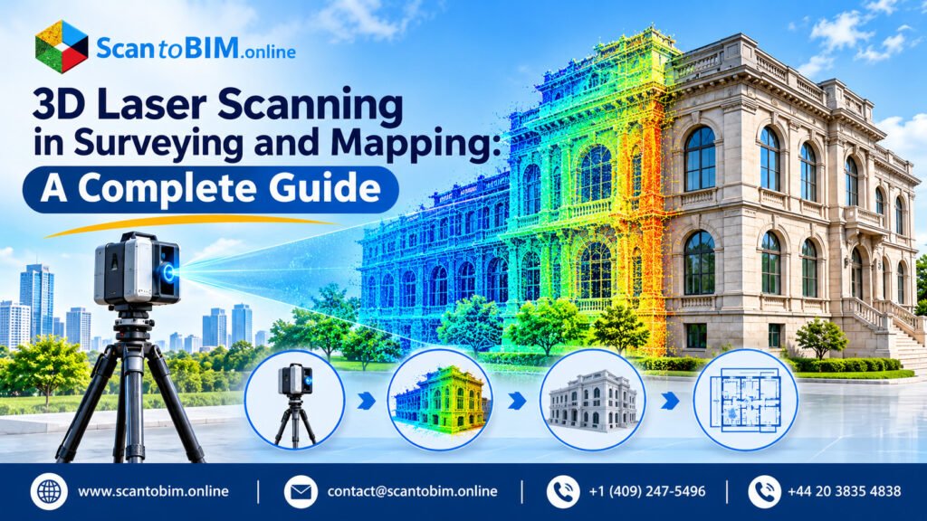
From each sweep, surveyors get a point cloud, a 3D record made of millions of measured dots. Each dot carries its own location. Together, the dots form a digital copy of the space as it stands today.
With that copy, teams get far more out of an existing conditions survey. They no longer have to guess in the field which dimensions will matter later. Back in the office, architects and engineers can:
-
- Measure any wall, beam, or pipe from their desk
- Work out volumes and floor slopes
- Map site levels without sending a crew back
To trust those measurements, though, teams need to know how surveyors capture each point.
How Does 3D Laser Scanning Work?
Surveyors rely on one simple fact for every point: light travels at a known speed. They use that fact to work out how far away each surface is. They can choose between two types of scanners to do it.
-
- Time-of-Flight:Surveyors shoot out short laser pulses and measure how long each takes to return. And then they convert that travel time into a particular distance. The crews choose these units to work outdoors because they can measure over long distances.
- Phase-Based:Surveyors send out a constant beam and measure the change in the returning light wave. These units lose some range, but they gain speed and fine detail. Crews pick them for crowded mechanical rooms and other close-range interiors.
Surveyors get the same core output from both methods. They record each point’s X, Y, and Z position plus how strongly the surface reflected the laser. They also take panoramic photos during the scan to add true color to each point. Clients then find point cloud surveying easier to follow, because they can explore a colored cloud like a photo.
Surveyors still have to weigh all this against the methods they already trust.
3D Laser Scanning vs Traditional Surveying
Surveyors have relied on traditional methods for decades. They use total stations, GPS rovers, and tapes to record one point at a time. They get accurate points, but only a thin picture of the whole site. If they miss a slab dip or a hidden pipe, they have to drive back and measure again.
With 3D laser scanning for surveying, crews close most of those gaps in one visit. They see the difference in three places:
-
- Coverage: Crews record millions of points from each setup instead of picking points one by one.
- Follow-up: Teams measure missed details from the scan instead of going back to site.
- Safety: Surveyors capture busy roads, active sites, and tall facades from a safe distance.
Firms pay for those gaps well beyond a single project. An FMI study for PlanGrid found that poor project data and miscommunication caused 48% of US rework. The study put the cost of that rework at about $31.3 billion in 2018.
Surveyors have one more light-based option to consider, though, and that’s LiDAR.
3D Laser Scanning vs. LiDAR
People in AEC use “LiDAR” and “3D laser scanning” as if they mean the same thing. They’re half right, since both measure distance with light. In practice, though, they use each term for a different kind of job.
LiDAR, short for Light Detection and Ranging, usually means scanners mounted on drones, aircraft, or vehicles. Crews fly or drive these systems over forests, highway corridors, and whole city blocks. They use the data for large-area laser scanning and mapping in GIS, the mapping software planners use. Architects can’t get the millimeter detail a renovation needs from it, though.
3D laser scanning usually means terrestrial laser scanning, or TLS. Surveyors set these scanners on tripods inside buildings or on job sites. They get much denser and more accurate data this way at close range. Designers rely on that accuracy for existing conditions of modeling. They also use it in plenty of places beyond design.
What Are the Main Applications of 3D Laser Scanning?
Owners, designers, and contractors use close-range scan data across a building’s whole life. They each tap into it at a different stage:
-
- As-built records and adaptive reuse: Architects turning old buildings into new uses need to know what really exists. They use laser scanning for existing conditions to design against the actual building as opposed to old blueprints.
- Site and terrain mapping: Civil engineers map uneven ground and work out how much soil needs to be moved.
- Historic preservation: Teams of preservationists sweep landmarks, building a permanent digital record. If fire or storm ravages the structure, they turn to that archive to assist in its rebuilding.
- Quality checks during construction: Contractors use reality capture to check the flatness and level of freshly poured concrete slabs. They also compare installed ducts, pipes, and wiring to the coordinated model.
All of these teams start from a point cloud. Most of them can’t draw or model inside a cloud of dots, though. They need one more step first.
How 3D Laser Scanning Supports Scan to CAD and Scan to BIM
Design teams need lines, walls, and objects, but a raw point cloud gives them only measurements. They need skilled drafters or modelers to turn one into the other. They usually pick one of two routes, depending on the project.
Drafters handle the first route, which is 2D. By dividing the point cloud into horizontal and vertical segments, they create Scan to CAD Drawings in AutoCAD. They trace those slices into floor plans, elevations, and sections. Teams choose this route for simple renovations and space planning.
Modelers handle the second route, Scan to Revit, and more owners now ask for it by default. They bring the point cloud into Revit and trace it into walls, doors, steel, and pipes. In Revit they use point cloud modeling to give data to each element such as size, material and type. The end result is a Building Information Model, or BIM, that the entire team can coordinate around.
Owners who opt for point cloud to BIM services are usually looking for LOD 300 or 350 models. They use LOD, or Level of Development, to set how much detail each element carries. At these levels, they get existing elements at accurate size, shape, and location. They can check the exact requirements in BIM Forum’s LOD Specification.
Owners only see the payoff from that model, though, once the project moves into design and construction.
Benefits of 3D Laser Scanning for Surveying and Mapping
Most AEC leaders now treat scanning as risk control, not an extra cost. They see the payoff in four places:
-
- Fewer return visits: Crews capture everything in view, so “we forgot to measure that” stops being a problem.
- Fewer clashes: Designers check new ducts and pipes against scanned beams in Navisworks, Autodesk’s clash-checking software. They fix clashes on screen, which costs far less than fixing them on site.
- Safer fieldwork: Crews spend less time on live roads, damaged buildings, and risky industrial sites.
- Faster schedules: Teams scan and process in days what used to take weeks of hand measuring. They can then start design sooner.
Contractors feel that last benefit most right now, because skilled labor is hard to find. In the 2025 AGC and NCCER workforce survey, 92% of contractors reported trouble filling open positions. With crews this stretched, they can’t afford to lose days to repeat site visits. They only get these benefits, though, if they hire someone who handles scan data well.
How to Choose a 3D Laser Scanning Service Provider
More operators are entering the market as scanning hardware gets easier to buy. Many of them can capture a scan, but far fewer can turn it into something engineers can use. Clients usually discover that gap when they receive a huge file nobody can design from.
Before signing with a provider, ask these questions:
-
- Can they model, or only scan? Look for in-house architects and engineers who deliver as-built modeling services. A provider who only hands over raw point clouds leaves the hard part to you.
- Will they share registration reports? Registration is the step where technicians line up separate scans into one cloud. A reliable provider shows you the alignment error at each step.
- Can they handle the data? Point clouds can reach terabytes, so ask how the provider stores and transfers files securely.
- Do they define the scope up front? Good providers of reality capture services agree on what the model needs to show before anyone scans.
Providers that offer full 3D laser scanning services, from capture through modeling, also follow a clear, repeatable workflow. You can use that workflow to spot the ones who don’t.
3D Laser Scanning Workflow: From Reality Capture to BIM
Most providers run scan projects in the same four phases. Project managers who know these phases can plan field and office work around them.
-
- Planning and site control: The team agrees on how much detail the model needs. Surveyors then tie the scan to State Plane, the coordinate system US surveyors use for each state.
- Data capture:Field crews move the scanner around the site in a planned pattern. They overlap each setup; no corner is left behind a column or wall.
- Registration and processing:Back in the office, technicians combine hundreds of scans into one single, aligned point cloud. This is done using software like Leica Cyclone or Autodesk ReCap Pro.
- Modeling and quality checks: Modelers turn the cloud into Scan to CAD drawings or 3D models. During point cloud modeling in Revit, they lay the cloud over the finished model to check every element.
Teams that rush an early phase usually pay for it with rework later.
Conclusion
Teams make better decisions when they start from what’s really on site. With 3D laser scanning in surveying, they capture that reality in a single visit. They can then measure, model, and check work from one trusted record. With labor tight and margins thin, they can’t keep paying for repeat site trips and rework. So before you order laser scanning for existing conditions on your next project, decide what the scan must deliver. Then plan the capture around it.
Originally published at https://www.scantobim.online.